Tuesday, May 3, 2011

Glacial Landforms


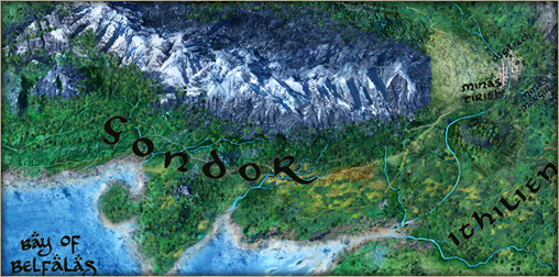
This Misty Mountains in middle earth are home to some of the largest glaciers the inhabitants of the land know. These glaciers occur when snow metamorphasize, which means the snow becomes more and more dense from repeated freezing and thawing, until after a long period of time it gets a bluish color.


Although glaciers are not present in every part on the Misty Mountains, the landforms are still greatly affected by the movement (advancement or ablation) and distribution of till, or the boulders, gravel, and sand left behind by the glacier. One of those landforms is a horn, or a pyramid shaped peak formed by cirque erosion on every side of the mountain.


Another landform that is common among the mountain region and other regions around middle earth are fjords. Fjords are glacial troughs (or U-Shaped valleys) that are filled with water due to sea level rise. The location of the statues of The Argonath is a fjord. Usually at the top of the fjords is an Arete, or a sharp, jaged, ridge that separates two glacial troughs.


https://segue.atlas.uiuc.edu/uploads/sgmartin/landscape.jpg
http://wwarii.com/lotrmaps.net/images/maps/misty-mountains.jpg
http://www.earth-issues.com/wp-content/uploads/2011/02/3690_large.jpg

Thursday, April 7, 2011

Weather of Middle Earth

In the land of Gondor in middle earth, a weather phenomenon occurs that confuses the natives of the land, and that is unmoving clouds that stay in the air all day and move very little if at all. The reason this happens is because of an unstable airmass that comes up over the mountains and lifts the condensation level. These air masses rise without help from any other external source.


Another phenomenon that that has only occurred a few times in middle earth history is the tornado that has struck Shire abut luckily did not cause much damage. Tornados are violent air masses that extend off thunderstorms and touch down to the ground. Tornados occur when large cool polar air masses meet warm tropical air masses. When the tornado touches down, winds of up to 300 miles per hour can occur. The reason the damage was minimal was because houses in Shire are built under ground and in hills so the Hobbits were safe from flying debris and the intense wind.


Often times these immense storms cause extreme lightning which is a result of opposite charged particles attracting and form a "stepped ladder" and as soon as there is a conductive path (when the particles are ground) the negative charged particles run down the ladder and cause a visible strike of lightning. 


Image sources:
http://blog.weflyspitfires.com/wp-content/uploads/2010/10/storm.jpg
http://stalinsmoustache.files.wordpress.com/2010/01/shire02.jpg
http://img233.imageshack.us/i/middleearthmapwallpaper.jpg/sr=1

Wednesday, March 2, 2011

The Dead Marshes and Shire

The Dead Marshes are located northwest of Mordor and are a graveyard to Elves, Men, and Orcs. The marshes are formed by runoff water from another location gathering in an enclosed area. This area acts as a water table. A water table is an area of water that is separated by an impermeable zone.


The reason the bodies are preserved so well is because of peat that is present in the marshes. Peat is formed by the buildup of organic particles which makes it rich in minerals and fertile. This helps keep the bodies look like they are recently deceased when in reality they could be months old.


Shire is located in the north west region of middle earth and is home to the Hobbits. Shire is a transport limited landscape. This means that the heavy amount of vegetation (in this case grass) limits the rate at which erosion can happen. This makes Shire an ideal place for Hobbits to live in peace. Also, since the houses are underground, they are very well insulated.


Images cited:
http://images.wikia.com/lotr/images/4/48/Dead_Ones.png
http://scrapbook.theonering.net/scrapbook/group/911/view/7730
http://www.exploring.co.nz/static/images/7/117-hobbit-holes-hobbiton.jpg

Monday, February 14, 2011

Mordor and its Geography

In the land of Middle Earth, there are many geographical landforms, but one of the most well known is the large volcano located almost in the center of Mordor called Mount Doom. Mount doom is an extremely active composite volcano which is clear because of its tall, steep slopes and constant lava flow and eruptions.


Because of Mount Dooms constant activity, it is growing due to the nonstop deposit of tephra and hardening lava. The lava that is being emitted from this volcano is felsic, which is more viscus and explosive. It is also clear from this picture that Barad-dûr, the tower with the eye of Sauron on top, was constructed on volcanic neck or dike. This is a result of magma formations  underground being exposed by erosion. There are also dikes that continue from Barad-dûr all the way to Mount Doom itself showing there are large systems of underground magma flows.


It is clear that the rock on the surface of the volcano is jagged which indicates thats it is A'a basalt rock; A'a meaning the basalt (an igneous rock) is sharp and has a rough surface, which you can see from that picture.


Pictures links:
http://therookiecynic.files.wordpress.com/2010/10/mordor.png
http://www.tolkienforums.com/Mount_Doom.jpg

Wednesday, January 26, 2011

Introduction

This blog was created by Alex Hernandez.

The location that I chose was the fictional land of Middle Earth as seen in the classic trilogy, The Lord of the Rings.


The reason that I chose this location is because the Lord of the Rings trilogy was one of my favorite series of movies when I was younger and now that I have a new viewpoint on geography, re-exploring this fictional land would give me a new appreciation for the movies. As my knowledge on geography increases, so will my awareness for geographical landforms across this land. Also, this land has such variety in physical geography there will be a lot to look at. I am very excited for this unique project.